Services
RESEARCH & INNOVATION
At Assimila, our highly skilled team believes in innovation at every step. We exploit multi-sensor products and create new software tools to create knowledge from data.
Data assimilation and modelling
Observations from optical, microwave and synthetic aperture radar sensors, can be used to derive information about surface vegetation – crop growth or the state of forests, for example. Such information can be used to support farmers and the wider agro-inputs industry; and to understand land-use change and carbon stocks, to give just a few examples of the potential.
Land surface parameters from Earth observation
Assimila and partners at University College London have developed innovative data assimilation techniques to combine satellite observations of the land surface with radiative transfer and other physical models to provide information about the land surface and vegetation state, such as leaf area index.
Crop modelling
We are also combining Earth observations and weather data with physically based crop models, to develop crop monitoring, yield forecasts and benchmarking.
See how this work is being used to develop solutions for comprehensive agricultural information systems.
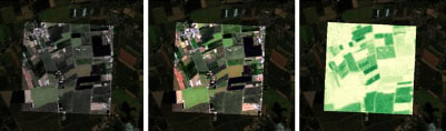
Original Sentinel-2 data, atmospheric corrected image and map of leaf area index (LAI)
Example projects
More on data assimilation and modelling
Land surface parameters from Earth observation projects:
Crop modelling projects:
Geocomputing
Today there is a vast array of Earth observation data available – much of it free. For example, the EU Copernicus programme offers full and open access to all Sentinel data products, from coarse (1000-500m) to high resolution (10-20m).
Such data offer many opportunities, but also some challenges. Where do users get the data? What data products are available? How do users process vast amounts of Earth observation data?
We understand how complex and time-consuming it can be, so at Assimila we have developed novel and innovative geocomputing techniques to streamline the entire process of acquiring, processing and visualising Earth observation data.
Acquisition – we have developed automated downloaders to obtain and store vast amounts of Earth observation data in a Cloud Optimised GeoTiff (COG) format. You just need to specify what data are required, the location and the time frame!
Processing – large amounts of Earth observation data require vast amounts of computing resources. We use virtualisation from virtual machines to Doker images and high-performance computing from JASMIN to Google Earth Engine. We use the power of xarray and dask to enable multi-dimensional Earth observation data analytics from data assimilation to machine learning.
Visualisation – we make it easy for you to access and visualise data the way you want. We have developed several tools from simple REST (representational state transfer) interfaces to complex Jupyter Notebooks to allow a simple way to obtain and visualise data, display time series, overlay map features, create custom animations and much more.
See our Data and Solutions section to find out more about how we apply these geocomputing techniques to provide you with accessible data.

Assimila Knowledge
Actionable information can only be provided when there is a deep understanding of all the elements of the processes that generated that information.
We understand Earth observation data, the complexities, the advantages and the limitations, for instance the complexity of performing an atmospheric correction for different sensors. We also understand land surface processes, for example the complexity of wildfires in Chile. We go deep into climate datasets to derive Climate Risk Indices and we use radiative transfer models together with Earth observation data to monitor crop yield.
We speak uncertainties, data assimilation, optimal estimation, and time series analysis. We do not produce per-sensor products, we use all sensors required to fulfil a requirement.
Innovation for us is using the right elements, the best data, the best techniques and our Assimila knowledge.
And finally, we always corroborate our findings against any kind of validation data we can obtain, either ground truth data or a product that has been fully validated. We publish scientific manuscripts, present at scientific conferences and take our science to the world to be scrutinised.
We learn and we improve.